A Family Connection
Posted: April 20, 2014 Filed under: Uncategorized | Tags: Birmingham, Birmingham History, British History, coffin furniture, Family History, funerary traditions, History, Jewellery Quarter, maps, Museum, Newman Brothers 2 Comments
Late 19th-century map showing Fleet Street. Caroline’s daughter, also called Caroline, lived briefly at number 3 Fleet Street in 1891, located near the corner of Newhall Street. Just a stone’s throw away, she may well have seen the construction of Newman Brothers, which began in 1892.
Family history never ceases to amaze me, especially in how we can often unknowingly mirror the endeavours and actions of our ancestors. In fact, a recent discovery of an ancestor working in the funeral trade in Birmingham over 150 years ago, and then of her daughter living on Fleet Street, just ten doors down from what was to become Newman Brothers Coffin Works (my current place of work) is almost poetic symmetry for me. For those unfamiliar with the project, Newman Brothers made coffin furniture for over 100 years between 1894 to 1999 on Fleet Street in the Jewellery Quarter. But failing to meet the demands of changing-industrial processes, largely dictated by the ‘plastics revolution’, as well as simply running out of steam, meant that Newman Brothers finally closed its doors in 1999, leaving everything behind. Everything is the operative word here, because everything from machinery, coffin handles, breast plates, company ledgers to a bottle of whiskey along with cans of soup were discovered. These objects will form the basis of Birmingham’s latest heritage attraction, allowing people to step back in time and experience the history of this company and of this trade.
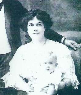
©Sarah Hayes. My great-great grandmother, Caroline Wilkes, daughter of Caroline Derkin, who was living on Fleet Street in 1891.
My connection to this trade is through my great-great-great grandmother, Caroline Derkin, who at the age of 17 was described as a ‘coffin-furniture maker’ on the 1861 census, the year that Prince Albert died. Discovering that I have a direct connection to this trade through one of my ancestors was a special moment indeed, and has fuelled my passion for this project even further. Coffin furniture covers a broad spectrum of products and as there was a division of labour between genders at this point, it’s most likely that Caroline was either working in the ‘soft’ furnishings division of this trade, making shrouds, linings and other textile-based products, or equally feasible is that she may have been working on the more industrial side, operating fly presses for cutting and piercing metal, another female-oriented role.
In 1851, there were nine master-coffin-furniture manufacturers in Birmingham, but the ease with which coffin furniture could be made, meant that goods could also be produced by a number of other non-specialist metal firms who made similar products, using the same industrial processes.This makes it difficult to pinpoint exactly which company Caroline was working for, but as she was living on Cecil Street in the New Town area of the city, it’s likely therefore, that she was working within walking distance of her home, as was the norm during this period.
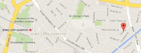
The red pin shows the location of where Caroline Derkin was living in 1861 in the New Town area of the city.
But, regardless of where she was working, it’s her connection to this Birmingham industry and more specifically, her direct connection to me and her legacy to my own story, that somehow brings me closer to her, and in a funny sort of a way, is an appropriate epitaph to our family’s history. She made coffin furniture and I’m attempting to preserve it. And it’s exactly that, the personal sense of preserving her story in my endeavours to preserve the history of Newman Brothers’ that has made this project yet again even more personally satisfying. What she’d make of a museum dedicated to the history of coffin furniture 150 years on is beyond me, but the story of Caroline Derkin has brought me closer to a chapter of Birmingham’s history and somehow for me, anyway, legitimised my role in preserving and exhibiting the history of this important Birmingham trade.
Keep up to date with progress @CoffinWorks and via http://www.birminghamconservationtrust.org
Sarah Hayes, Collections and Exhibitions Manager @CoffinWorks
Follow me @HayesSarah17
Share this:

Medieval ‘Footprints’ in Birmingham
Posted: July 25, 2013 Filed under: Medieval History | Tags: Archaeology, Birmingham, Birmingham History, British History, Burgage, History, London, maps, Medieval, Middle Ages, Museum 5 Comments
© Birmingham Museums
The title of this blog doesn’t refer to the sort of footprints you leave behind in the mud or snow, but rather the type that define the area or space occupied by a building, or in this instance the boundaries of a burgage plot. By ‘burgage’, I’m referring to the long and narrow strips of land arranged along street frontages that functioned as the basic units of a town that could be built upon.
So perhaps footprints isn’t the best word to use, because I’m actually referring to plot boundaries rather than the actual buildings. But, footprints is, in another sense, an appropriate word to use as it calls to mind the idea of ‘evidence’ left behind and that’s exactly what the landscape historian and archaeologist has to work with when attempting to reconstruct medieval towns. For a city that’s never been overly keen on preserving its most recent heritage, it might surprise you to learn that Birmingham has some of these medieval ‘footprints’ left.
Burgage plots were characteristically long and narrow, but pressure to subdivide land on account of prosperity and population growth resulted in subdivision of plots making them smaller as you can see in the top right-hand corner of the image. © Birmingham Museums
There are around several of these medieval burgages left in the city centre located in the Digbeth area of town, which appear to conform to their original 13th-century boundary lines. The idea of property boundaries surviving is probably slightly underwhelming for a lot of people, who’d much rather see the actual medieval buildings, but the boundary lines are largely, in fact, an older remnant of medieval towns. Moreover, their story of survival is a fascinating product of the early legal status our ancestors attributed to land. After all, it was owning land, a burgage, that made a townsperson a burgess giving them particular privileges like participating in the collective decision-making of a town. Burgess is in fact, derived from the word burgage which itself comes from the Old French word, burgeis, simply referring to an inhabitant of a town. Buildings, although more appealing, were the dispensable attributes of a property, as they came and they went, but land was preserved precisely because of its power to bestow status on a person, and not to forget its potential to make them money.

The frontages of Birmingham’s surviving burgages located in Digbeth just off Park Street. © Sarah Hayes 2013
We need look no further than London after the great fire of 1666 to help explain how and why burgage plots survive. This event brought disastrous consequences on the city burning down a third of London with an estimated ninety-thousand people displaced.
But for some like Sir Christopher Wren and the Royal Society, this was a golden opportunity. They proposed to rebuild London on the basis of an ordered grid system in place of the disordered medieval streets, but this didn’t happen for a few reasons. First, a complete redesign would have taken too long but more specifically here, the property boundaries, although now virtually impossible to pinpoint on account of the absence of the buildings, were still protected by law.
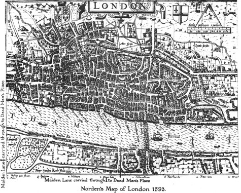
Map of London in 1593. Notice the disorder of the medieval streets. Source: http://www.medart.pitt.edu/image/England/London/Maps-of-London/London-Maps.html
In fact, it would have involved intervention by the government to implement a complete redesign, and the difficulty of compensating people or transferring their property was a messy and complicated task. The actual reality of rebuilding London after 1666 involved surveyors like Robert Hooke walking the charred streets with residents, armed with available property deeds as well as twine and wooden posts to ‘stake’ out their original plots of land. This example serves to illustrate how legality ensured longevity. That’s to say, that it is precisely the early legal status assigned to boundaries that ensured their survival very often into the 19th century and as recent as the present day in many cases.
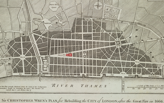
Sir Christopher Wren’s proposal for London after the Great Fire of 1666. Source: http://www.architecture.com
‘So what’ I hear some people say, but when you appreciate that we have a stretch of original medieval burgage plots still in Birmingham, standing on the same 13th-century boundary lines, that is a remarkable feat of survival by any standards. What fascinates me the most about this survival though, is that these plots would have been carefully measured out by some of Birmingham’s medieval residents using the town’s very own measuring rod or pole to achieve the intended widths and lengths. These boundary lines, now official, would have been recorded in court rolls and subsequent deeds of transfer. In 13th-century Birmingham one of these plots would have cost you eight pence or four pence for half a plot, incidentally much cheaper than the one shilling fee in other parts of the country.

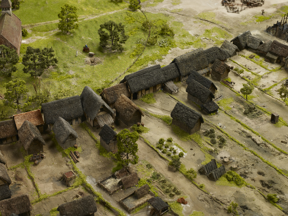
An impression of what we think the Digbeth plots looked like in the 13th century. Located in the heart of the town, this was a prime spot and the pressure to build here must have been great. © Birmingham Museums
Likewise, burgage widths vary a great deal across the country. In Birmingham, they were probably originally around five metres wide and anything up to 60 metres in length, but in Stratford-upon-Avon the average plot was around 15 metres wide! If you’re lucky, these exact widths and lengths are recorded in official documentation like borough charters as in the case of Stratford. But as Birmingham doesn’t have a borough charter, how do we know that these properties are standing on the same original medieval boundary lines?
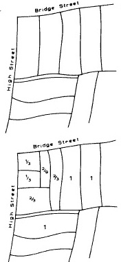
We can see what original burgage plots would have looked like when a town was first laid out as illustrated at the top of the image. Once a town started to prosper, plots were subsequently subdivided as depicted in the bottom half of this image. Source: Ideal and Reality in English Episcopal Medieval Town Planning, T.R. Slater
Good question, and the answer is a mixture of hypothesis and fact. Local specialists like George Demidowicz used a technique known as deed regression, which involves tracing boundaries back as far as possible by using property deeds. Such documents record the positions and measurements of a townsperson’s land and luckily for Birmingham, we have a handful of surviving deeds which reveal the transfer of ownership for some of the town’s residents. But this isn’t the case for the entire original medieval town, as we only have this information for sections of the buildings around the Digbeth plots. The deeds tell us that the owners in this part of town ranged from early forms of local government like the Guild of the Holy Cross as well as prominent townspeople such as the Inge and Phillips families.
Specialists also turn to map regression, a technique that uses maps from different periods to compare changes over time and also to identify any continuity. By continuity I’m specifically referring to boundary lines that look ‘ancient’. This involves identifying classic parallel sequences of long strips of land which are often found on19th-century maps denoting the presence of burgages. If these same long strips are visible on even earlier maps like tithe and estate records, there’s a very good chance that we are looking at original burgage plots as laid out when a town was founded. A town’s layout up until the 19th century was often very stable and reflected the original burgage pattern of a town. And although burgages were subject to internal divisions, these later divisions did not normally alter or remove earlier boundaries. This has proven to be the trend across the country. In York, for example, burgage boundaries have survived unchanged from the tenth century, and when plot boundaries were eventually destroyed due to new developments, this change normally occurred in the second half of the 19th century.
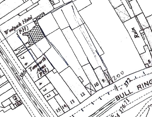
A classic burgage pattern depicted on a 19th-century map. This sequence of burgages has since been displaced by modern developments and lies somewhere underneath Selfridges. Also note how the plots have been subdivided, but the earlier original boundary lines nevertheless survived.
In many instances, therefore, we can be sure that when we see long and narrow strips of land on 19th-century maps in places with a medieval past, there’s a very good chance we are looking at some of the original property boundaries of a town. Although the majority of property deeds we have for Birmingham only stretch back to the 1500s, the same rule applies as above: if map regression demonstrates that burgage boundaries do not alter until the 19th century, there’s no reason to suppose that they would have altered by the 16th century. That’s where hypothesis comes in, but this hypothesis is based on detailed research as well as numerous case studies from around the country. Although we can’t actually legitimately trace the Digbeth plots back to the 1150s when Peter de Birmingham founded the town, we can, with the help of both map and deed regression along with the presence of 12th and 13th-century archaeology from the plots, confidently place them at the very latest in 13th-century Birmingham. What is even more satisfying though, is that the forthcoming £150m Beorma Quarter set to transform the area with a 27-storey tower as well as 600,000-square feet of offices, retail and leisure space, will still retain the existing boundaries in the design of the new development. So fortunately, it looks like the medieval relics have a long life ahead of them yet!

A proposal for the forthcoming Beorma development. The new development will be constructed on the same medieval boundaries thereby maintaining around 700 years continuity. Work is due to begin in September this year and will start with the construction of a hotel and the refurbishment of Digbeth’s grade-II listed cold storage building. Source: http://www.trevorhorne.com
Birmingham’s burgages are an incredible vestige of our medieval past in a city that’s rarely been sympathetic to its heritage. For me however, they’re simply special because of their ability to take us back to Birmingham’s beginnings as a recognisable commercial and soon to be urban centre. Just as those London residents who walked the streets with Hooke in 1666 staked their claims and protected their boundaries, this stretch of burgages in Birmingham similarly has the power to evoke the presence of people preparing and planning their very own town. In fact, the truly remarkable thing for me about these seemingly trivial features is the knowledge that around 700 years ago a few of Birmingham’s residents were protective of the very same boundaries we can still see today. In this way these medieval ‘footprints’ serve as a gateway with the power to take us back to the point when Birmingham’s inhabitants were laying the foundations of their town and creating the blueprint of what was to become the basis of this great city.
Follow me @HayesSarah17


")


